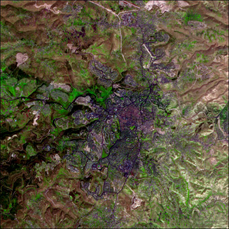
Jerusalem
The ancient city of Jerusalem is cloaked in shades of purple in this image
based on data acquired by the Advanced Spaceborne Thermal Emission and
Reflection Radiometer (ASTER) on NASA's Terra satellite on April 3, 2000.
Using shortwave infrared, infrared, and red wavelengths (ASTER bands 4, 3, and 2)
in the traditional red, green, and blue channels of the image creates this
false color version of the city in which developed areas are purple, vegetation
is green, water is deep blue or black, and naturally bare (or thinly vegetated)
ground is pinkish-brown.
Just to the right of the center of the scene is the downtown area, which appears
a brighter purple than the surrounding parts of the city, perhaps because it is
more densely developed or the materials or types of structures in that part of
the city are different. At the southern edge of the area, a bright green spot
shows the location of the Ha Atsma'ut Garden.
Due east (right) of the garden, an irregular polygon of light purple shows the
boundaries of the old city, surrounded by a 400-year-old wall built by the Ottoman
Turks. The old city is divided roughly into quarters: northeast is the Islamic Quarter,
southeast is the Jewish Quarter, southwest is the Armenian Quarter, and northwest is
the Christian Quarter.
Along the old city's eastern edge, a pinkish rectangle is the plaza on which the Dome
of the Rock (dot in center), an Islamic holy site, is located. Just to the south is the
Al Aqsa Mosque. This area also encompasses land that is sacred to Jews. Known as the
Temple Mount, the area is believed to be the site of the temples of the Jewish kings,
including King Solomon and King David. On the eastern edge of the old city, beyond the
Temple Mount, lies the Mount of Olives.